Dun Gerashader. (NG 4892 4527) Visited
29th November 2016
People driving from Portree to Staffin will pass Dun
Gerashader without a second thought – just another pile of stones. Easily accessed - drive approximately one
mile from Portree on the Staffin road, park at the large layby on the right immediately
before the Torvaig Road. Enter the field
via the gate just along the Torvaig road.
(Please enusre you close the gate carefully as there are cows grazing here; placidly grazing, these did not appear to be the fairy cows mentioned later) ) The short route to the Dun is boggy, trampled by cows and waterproof footwear is needed as there are a few narrow burns to cross.
The Dun area is best accessed from the South (head left as you enter the field).
The Dun area is best accessed from the South (head left as you enter the field).
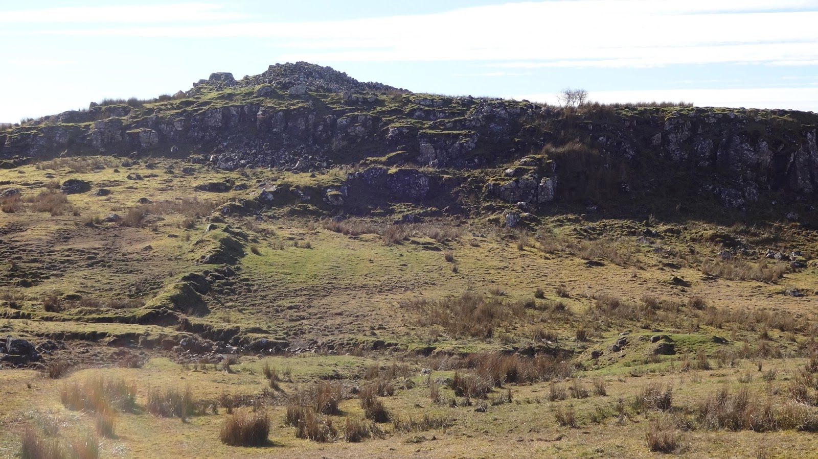
Described by RCHMS as an Iron Age fort,
is situated on a flat-topped ridge near the River Chracaig, No record of excavation has been found so
dating can only be approximate. I would
guess it is older than most of the Skye brochs and is probably early Iron Age,
maybe 500-600BC.
The most unusual feature, best seen from the Canmore aerial
photograph of 1989, are the three lines of massive boulders (Donaldson-Blythe claims
four[1])
to the south.

These were perhaps
intended to be an obstacle to potential invaders and are compared by Donaldson
Blythe to “Chevaux de Frise” seen in later structures. The wall behind these boulders is massive
while what remains of the walls to the North, West and East are rather less
substantial.
The entrance to the dun is described as being near the
middle of the E flank, with the foundations of a gateway 8ft 6ins wide.

Entry from the south, through the outer boulders would have been far easier but there is no evidence of a gateway there.
Just inside the south wall to the west, there is a clear outline which Canmore describes as an enclosure 28ft in length and 13ft in breadth.
Canmore also mentions a small oval structure 10ft long by 7ft broad on the inside of the second wall near its East end – we did not see evidence of this.


Although the cows we passed on our way to the Dun certainly belonged to a human crofter; it seems that in the past the fairies once inhabited or used this Dun to call in and count their cows.
In Skye, Fairy cattle are said to be speckled and red (crodh breac ruadh), and to be able to
cross the sea.
It is not on every place that they graze. There were not above ten such spots in all Skye. The field of Annat (achadh na h-annaid), in the Braes of Portree, is one. When the cattle came home at night from pasture, the following were the words used by the Fairy woman, standing on Dun Gerra-sheddar (Dun Ghearra-seadar), near Portree, as she counted her charge:
"Crooked one, dun one,
Little wing grizzled,
Black cow, white cow,
Little bull black-head,
My milch kine have come home,
O dear! that the herdsman would come!"[2]
Dun Gerashader offers amazing views all around.


There should be a clear line of sight to both Dun Borve and Dun Torvaig but neither are easy to pick out.

 From Gerashader we made our way to Dun Torvaig - which should be visible but is not easy to make out - I think it may be the lump to the right of the picture.
It is not on every place that they graze. There were not above ten such spots in all Skye. The field of Annat (achadh na h-annaid), in the Braes of Portree, is one. When the cattle came home at night from pasture, the following were the words used by the Fairy woman, standing on Dun Gerra-sheddar (Dun Ghearra-seadar), near Portree, as she counted her charge:
"Crooked one, dun one,
Little wing grizzled,
Black cow, white cow,
Little bull black-head,
My milch kine have come home,
O dear! that the herdsman would come!"[2]
Dun Gerashader offers amazing views all around.


There should be a clear line of sight to both Dun Borve and Dun Torvaig but neither are easy to pick out.


[1] Donaldson-Blyth,
Ian, (1995) In search of Prehistoric
Skye, Thistle Press 1995
[2] J G
Campbell (1900)., Superstitions of the Highlands and Islands of
Scotland, https://archive.org/stream/cu31924029909896/cu31924029909896_djvu.txt. Accessed 29/11/16
Alan Broch researcher,
ReplyDeleteThe Dun Gerashader purpose, to hold the animals and people that could not be taken in at the Dun Torvaig during an attack.
The higher part of Dun Gerashader would be the more defended part of the dun and the walls were layed out to make it more difficult to get access.
The Dun Torvaig was built to alert the area of attack from the sea and to hold the Chief of the area.
Interesting ideas. Any evidence?
ReplyDeleteHard evidence would be difficult to find....we can only make intelligent assumptions. Pity we cannot accurately date them. Certainly there are clear lines of sight from Torvaig to Gerashader and then onto Borve. Neither for could really hold that many people and animals..maybe just for the important ones?
ReplyDeleteAlan researcher,11 Ose.
DeleteTo be a good researcher and to try and work out what you are trying to find, you must transport your mind to that time.
I have for instance tried to find the symbol for a Brochs or Duns on ancient maps of Scotland made by past map makers in the late BC to Early AD.
I have been trying to translate Ancient Greek,
Latin,Roman,Phoenician into English but it has been more difficult due to words which are made up of different script.
I miss Tim and Lee who would have given me great help as they know many languages.
We must try and find some references from old scripts, maps, slave records, land ownership to find more about Brochs.
I am hoping to find a new Dun but have found the Dun field walls and saw something looking like a Dun but it was too late in the day to go on. It is new finds we need to try and solve, who built the Brochs and Duns.
Your work on ancient Greek is admirable. Shame that none of the original versions of Pytheas' voyage survive
DeleteJust come across another dun with lines of boulders obstructing the approach:
ReplyDeletehttps://canmore.org.uk/site/69627/aird-skye
Alan of Ose,
DeleteThe Dun I have still to visit has a right angle wall inside and possibly a small round structure.
When viewing using the satellite mapping things can look different when you are actually there.
I have also seen what looks like a chambered cairn further on by the Dun but looks can be deceiving but we live in hope.
We must keep looking.
Alan of Ose report,
DeleteI went to the area where I had spotted on the satellite map but I was disappointed that it turned out to be a Lime stone natural mound.
I also had a walk around the area which is near the bends before Carbost turn off.
There is a sharp bend with a water fall going under the road.
The car park is just before the ends on the right if you are coming from Struan.
The area has two Field Walls that end at burns and this gave me a clue of possible DUN OR BROCH near by.
On another day I went to another area near to Coillore. The area was to the right over a bridge and up a track keeping to the left of the burn where I found Two Black Houses which looked very old possibly 200 year old.
I have more areas that I want to survey which keeps the thought of finding an undiscovered Dun or BROCH or anything.
I carried on up the track for half a mile and the turned to the left up onto the tops of 5 small hills.
The hills were a perfect place to built a Broch or Dun, they were flat topped and had out crops of stone ready for building on.
It is a great place to go for a walk and to view the Cuillins with a clear view to the Outer Hebrides.
Can't visualise where you mean.. Grid ref?
DeleteHello Joy,
DeleteI forgot to put in the map reference, here they are
NG406326 looks like a fort or dun on satellite map
NG405328 looks like a chambered cairn on sat map
Area is North of Drynoch.
NG368375 looks like a fort or dun on sat map.
NG365373 There is two black houses next to burn but look very old.
The area is in sight of Coillore Farm ,it is the old road that you take to first old bridge and then turn right onto the path and follow until you see the hills on the left. It is well worth the walk to the top of the hills where the views are spectacular in all directions.
I had the feeling that the hills were used at some time long ago but nothing is left but short grass and stone out crops.
See you on Friday.
Alan of Ose.